This article contains affiliate links. If you book through them, I earn a small commission at no extra cost to you.
I was standing at the rim of a smoking volcano, snow crunching under my boots, staring down into a crater that glowed faintly red at the bottom. Behind me, a lake so blue it looked photoshopped. Ahead, nothing but white peaks for as far as I could see. That was Villarrica, on day four of what was supposed to be a two-week trip to Chile. I ended up staying six weeks. And the reason was simple: every time I finished one national park, someone on a bus or in a hostel kitchen would say, "But have you been to..." and name another park I had never heard of that sounded even better than the last.
Chile has 46 national parks. Forty-six. Stretched across 4,300 kilometers of the skinniest country on Earth, from the driest desert on the planet to the glaciers at the bottom of the world. You cannot visit them all in one trip. You probably cannot visit them all in five trips. But I have spent three separate visits trying, and what follows is my honest, ranked, opinionated guide to the 13 parks that I think matter most — the ones that made me rebook flights, rearrange itineraries, and question my life choices back home.
I organized these roughly north to south, which is also roughly driest to wettest, hottest to coldest, and least crowded to most crowded. For each park, I will tell you what makes it special, the best hike, how to actually get there, what it costs, and when to go. My top five ranking is at the end — and it might not be what you expect.
Before You Go: CONAF Ticketing
Chile moved to mandatory online ticketing for most national parks through PasesParques.cl. Buy your entry in advance — some parks cap daily visitors and sell out during peak season (December-February). The system is clunky and sometimes crashes, so don't leave it until the last day. I learned this the hard way at Torres del Paine when my reservation failed and I had to rebook for two days later.
The Far North: Desert and Altitude
Lauca National Park — Flamingos at 4,500 Meters
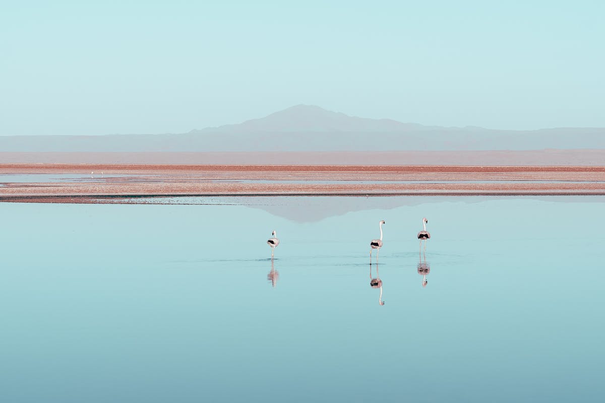
Most people fly into northern Chile for the Atacama Desert and never go further north. That is a mistake. Lauca National Park sits on the Bolivian border at altitudes between 3,200 and 6,342 meters, and it feels like visiting another planet. The altiplano here is vast, treeless, and impossibly quiet. Vicunas graze on bofedales — high-altitude wetlands — while Andean flamingos stand in shallow lakes that reflect the twin cones of Parinacota and Pomerape volcanoes.
I visited Lauca as a day trip from Putre, a tiny town at 3,500 meters that serves as the acclimatization base. The drive up to Lago Chungara at 4,517 meters was rough — my head pounded, my appetite vanished, and walking twenty meters felt like running a sprint. But the lake itself, sitting in the shadow of Parinacota's perfect snow cone, was the most beautiful single view of my entire Chile trip. And I say that having seen Torres del Paine.
Best hike: The Cotacotani Lagoons trail — a flat 8-kilometer loop past turquoise volcanic lakes. Not technically demanding, but the altitude makes everything harder. I was gasping after ten minutes and I consider myself reasonably fit.
Getting there: Fly to Arica, then take a bus or shared transfer to Putre (3 hours). From Putre, hire a driver or join a tour — there is no public transport into the park itself. Budget around $40-60 for a full-day tour from Putre.
Entrance fee: 5,000 CLP (~$5 USD) for foreigners.
When to go: April to November for clear skies. December to March is rainy season — the altiplano turns green, which is beautiful, but afternoon storms roll in daily and roads can flood.
Pan de Azucar National Park — Where the Desert Meets the Sea
This is the park nobody talks about, and I almost skipped it entirely. Pan de Azucar sits on the coast between Copiapo and Antofagasta, where the Atacama Desert drops straight into the Pacific. The landscape is surreal — bone-dry brown hills plunging into turquoise water, with cactus fields running right up to the cliff edges. It looks like Baja California had a baby with the moon.
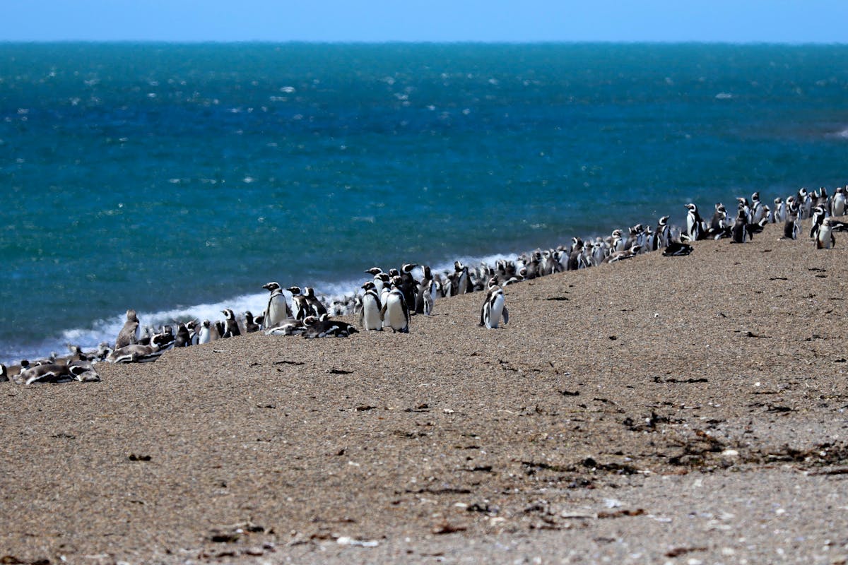
The reason to come here is the Humboldt penguins. A colony of several hundred lives on Isla Pan de Azucar, just offshore. Local fishermen run boat trips from Playa Los Piqueros — you get within maybe thirty meters of the island and watch the penguins waddling around on the rocks. There are also sea lions, pelicans, and on the right day, dolphins in the channel. I went in July and had the entire beach to myself. The boat captain said I was his only customer that week.
Best hike: Mirador Pan de Azucar trail — a 5-kilometer out-and-back that climbs to a viewpoint overlooking the island and the coast. Short but steep, and there is zero shade. Bring more water than you think.
Getting there: You need a car. The park is about 30 km north of Chanaral on the Pan-American Highway. There are no buses to the park itself. I rented a car from Copiapo for two days — worth it for the coastal drive alone.
Entrance fee: 5,000 CLP (~$5 USD). Camping is available at basic CONAF sites for about 8,000 CLP per night.
When to go: Year-round, but June to September offers the best wildlife viewing and coolest temperatures. The camanchaca (coastal fog) rolls in most mornings and burns off by noon — it is eerie and gorgeous at the same time.
The Araucania and Lake District: Volcanoes, Forests, Hot Springs
This is the part of Chile that feels like the Pacific Northwest got dropped into the Ring of Fire. The Lake District is green, wet, volcanic, and packed with more accessible national parks per square kilometer than anywhere else in the country. You could spend a month here and not run out of trails.
Conguillio National Park — Walking Through Prehistory
Conguillio does not look like any park you have visited before. The landscape is dominated by araucaria trees — those strange, prehistoric-looking conifers with the umbrella-shaped canopies that have been around since the Jurassic. They grow on the flanks of Llaima, one of Chile's most active volcanoes, creating this jarring contrast of ancient forest against black lava flows that are sometimes only decades old.
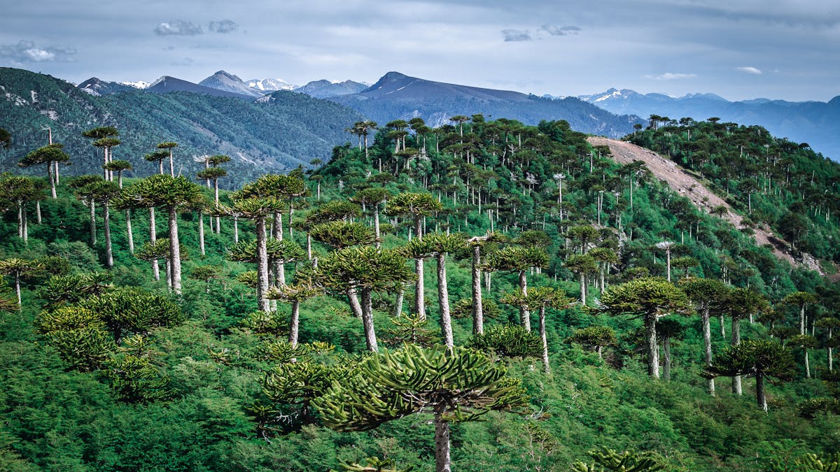
I spent two days here and could have stayed longer. The Sierra Nevada trail is a full-day hike that takes you through dense araucaria groves, over old lava fields, and up to viewpoints where Llaima dominates the entire horizon. The lava fields are strange to walk on — rough, black, and weirdly quiet because nothing grows on them. Then you step back into the forest and the birdsong is deafening.
Best hike: Sierra Nevada trail — 13 km, 6-7 hours, moderate. The last section gains elevation quickly and the views from the top over Lago Conguillio are worth the burning thighs. Alternatively, the shorter Araucarias trail (1.5 km loop) is perfect if you just want to walk among the trees without committing to a full day.
Getting there: From Temuco (about 2 hours by car), take the road through Melipeuco. In summer, there are occasional buses from Temuco, but they are unreliable. A rental car gives you much more flexibility. The park has two entrances — use the Melipeuco side for the best trails.
Entrance fee: 6,000 CLP (~$6 USD) for foreigners.
When to go: December to March for hiking. The park closes partially in winter due to snow. Spring (October-November) is underrated — fewer crowds, wildflowers, and the snow-capped araucarias are unreal.
Huerquehue National Park — The Best Day Hike from Pucon
If you are staying in Pucon — and you probably should be, because it is the adventure capital of the Lake District — Huerquehue is the day hike you cannot skip. The Los Lagos trail climbs through old-growth araucaria forest to a chain of three alpine lakes, each one more absurdly colored than the last. The whole thing takes five to six hours and it is honest-to-god one of the best day hikes in South America.
The first hour is the hardest — a steady climb through dense forest with exposed roots and some slippery sections if it has rained recently. Then the trail levels off and you start hitting lakes: Lago Tinquilco first, then Lago Chico, then Lago Toro at the top. Lago Toro was the payoff for me — deep turquoise, ringed by araucarias, with Villarrica's steam plume visible above the tree line. I ate my sandwich there and seriously considered not going back down.
Best hike: Los Lagos trail — 13 km loop, 5-6 hours, moderate. Start early to beat the afternoon clouds. The trail is well-marked but muddy in sections after rain.
Getting there: 35 km from Pucon center. Buses run from the rural terminal in Pucon to the park entrance in summer (about 45 minutes, 2,000 CLP). In shoulder season, you will need a taxi or rental car.
Entrance fee: 5,000 CLP (~$5 USD) for foreigners.
When to go: November to April. January and February are peak — expect company on the trail. I went in March and shared the lakes with maybe eight other people total.
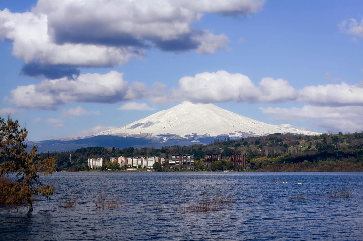
Villarrica National Park — The Volcano You Can Climb
You can see Villarrica from Pucon. It sits there at the end of the main street, snow-capped and gently smoking, daring you to climb it. And you should. The summit climb is one of the most accessible active volcano ascents in the world — you do not need technical mountaineering experience, just reasonable fitness and a willingness to get very cold and very tired.
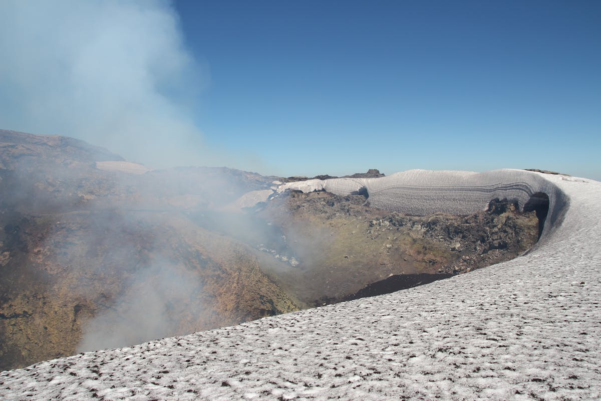
The climb takes 6-8 hours round trip with a guide (mandatory). You start at the ski center at 1,400 meters, climb through snow and ice using crampons, and reach the summit at 2,847 meters where you can peer into the crater and smell the sulfur. The descent is the fun part — you slide down long snow chutes on your backside, picking up speed, screaming, and arriving at the bottom in about forty minutes with soaked pants and a huge grin.
But Villarrica is more than the volcano climb. The park also has incredible hiking trails through monkey puzzle forests, and the area around Pucon is loaded with hot springs. After the climb, I soaked in the Geometricas hot springs for two hours and it was the best $25 I spent in Chile.
Best hike: The summit climb, obviously — but you need a licensed guide ($80-120 per person). For a non-volcano option, the Villarrica Traverse (3 days) crosses between Villarrica and Huerquehue and is spectacular.
Getting there: The volcano trailhead is 15 minutes from Pucon by car. Tour companies handle transport as part of the climb package.
Entrance fee: 6,000 CLP (~$6 USD). The summit climb fee is separate and included in your guide's package.
When to go: December to March for summit attempts. The park is accessible year-round — winter brings skiing to the lower slopes.
Nahuelbuta National Park — Araucarias Nobody Visits
Nahuelbuta is the other araucaria park, and I guarantee 95% of travelers to Chile have never heard of it. It sits in the Nahuelbuta Range, a coastal mountain chain between Temuco and Concepcion, and it protects what might be the largest and oldest araucaria forest left in the country. The trees here are enormous — some are over a thousand years old, their trunks as wide as cars.
I came here specifically because a park ranger at Conguillio told me to. He said Conguillio gets the tourists and Nahuelbuta gets the trees. He was right. I hiked the Piedra del Aguila trail to a rock outcrop at 1,400 meters and could see both the Andes and the Pacific Ocean at the same time. The forest was so thick the trail felt like a tunnel. I saw exactly two other hikers in six hours.
Best hike: Piedra del Aguila trail — 7 km out-and-back, 3-4 hours, easy to moderate. The viewpoint at the end gives you a panoramic sweep from the volcanoes to the sea.
Getting there: This is the catch — Nahuelbuta is remote and there is no public transport. From Angol (about 1.5 hours by car), a gravel road leads to the park entrance. The road is rough and a high-clearance vehicle is strongly recommended, especially after rain.
Entrance fee: 4,000 CLP (~$4 USD).
When to go: December to March. The road can be impassable in winter. The park sometimes closes without warning after heavy rain.
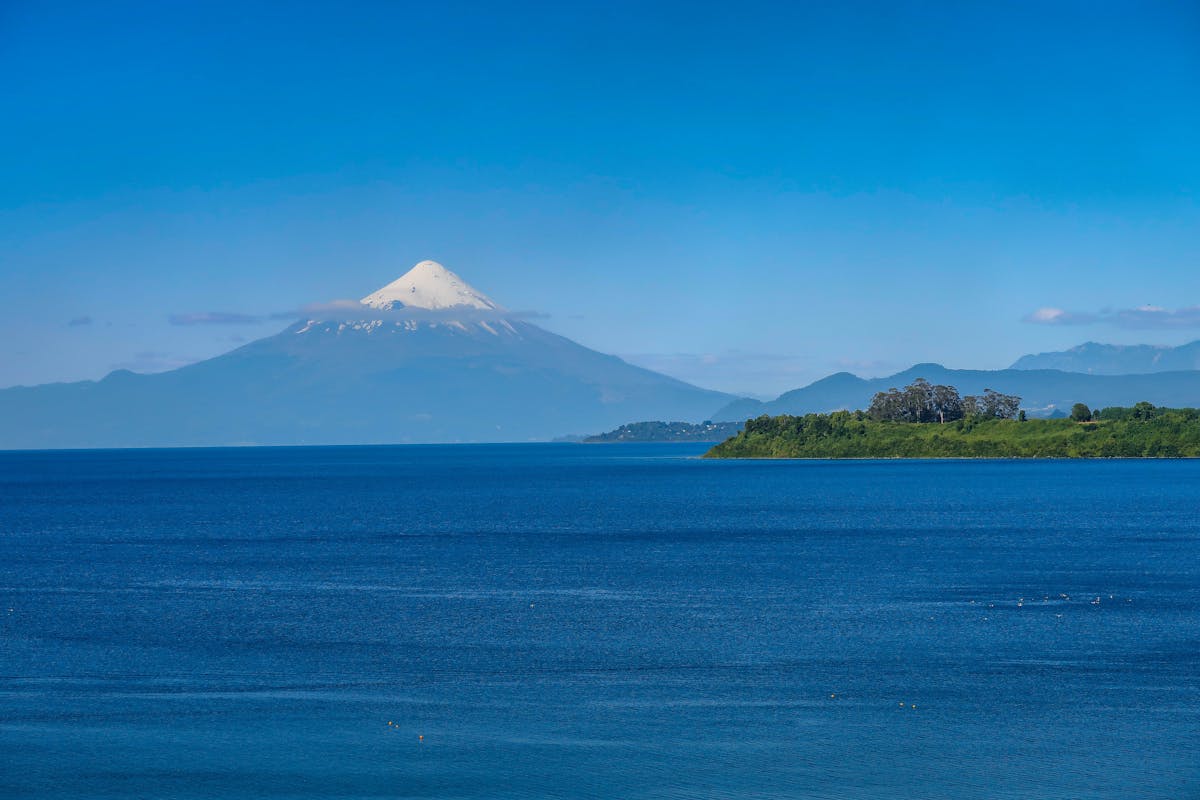
Vicente Perez Rosales National Park — Petrohue Falls and Osorno
This is Chile's oldest national park, established in 1926, and it contains probably the most photographed volcano in the country: Osorno. That symmetrical, snow-covered cone sitting above Lago Todos los Santos with Petrohue Falls in the foreground — you have seen this image a thousand times. But seeing it in person is different. The scale is what gets you. Osorno is not particularly tall (2,652 meters), but it rises directly from the lake with nothing else around it, so it looks massive.
Petrohue Falls is the most visited part of the park — a short walk from the parking lot to a series of bright turquoise rapids carved through volcanic basalt. It is gorgeous but crowded. The better experience is the Paso Desolacion trail (6 hours round trip), which climbs through dense valdivian rainforest to a viewpoint above the tree line. Hardly anyone does it.
Best hike: Paso Desolacion — 12 km, 6 hours, moderate to hard. Muddy in all seasons. Bring gaiters if you have them. The alternative is the easy Saltos del Petrohue loop (1 km, 30 minutes) for the waterfall views.
Getting there: From Puerto Varas (1 hour by car or bus). Regular minibuses run to Petrohue in summer. You can also take the lake crossing from Petrohue to Peulla as a day trip or as part of the classic lake crossing to Bariloche, Argentina.
Entrance fee: 5,000 CLP (~$5 USD). The Petrohue Falls walkway has a separate 5,000 CLP fee, which annoys everyone.
When to go: November to March for hiking. The volcano is often cloud-covered in winter, so if you are coming mainly for the views, wait for summer and check the forecast obsessively.
Chiloe and the Carretera Austral: Wild, Wet, and Empty
South of the Lake District, things get wilder. The roads get worse, the rain gets heavier, the forests get denser, and the tourists thin out dramatically. This is where Chile starts to feel genuinely remote, and the Carretera Austral — that 1,200-kilometer gravel highway through some of the most spectacular scenery in the Americas — is the thread that ties it all together.
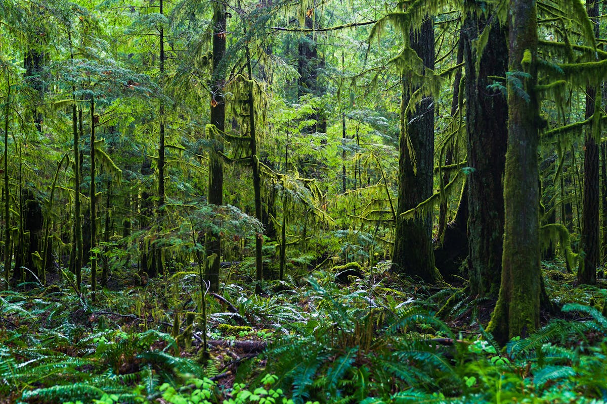
Chiloe National Park — Temperate Rainforest on the Edge of the World
Chiloe is already one of my favorite places in Chile — the stilted houses, the wooden churches, the curanto cooked in the ground, the persistent drizzle that gives everything a soft-focus quality. The national park on the west coast of the island is the wildest part: dense temperate rainforest backing onto empty Pacific beaches with enormous sand dunes.
I hiked the Dunas de Cucao trail, which starts at the small village of Cucao and follows the coast through forest and then out onto a long stretch of beach backed by massive dunes. The wind was ferocious. My rain jacket, which had been fine everywhere else in Chile, proved to be only partially waterproof. But the beach was empty, the surf was huge, and the light through the clouds turned everything silver. It felt like the end of the world in the best way.
Best hike: Dunas de Cucao — 8 km one-way along the coast. Flat but exposed to weather. You can loop back through the forest if you don't want to retrace your steps. The Tepual trail (shorter, 1 km) is a boardwalk through a tepual forest — gnarly, moss-covered trees growing out of a permanent bog. Weird and atmospheric.
Getting there: From Castro (Chiloe's main town), take a bus to Cucao (1.5 hours, around 3,000 CLP). The park entrance is a 20-minute walk from the Cucao bus stop. From Santiago, you can fly to Puerto Montt and take a bus or ferry to Chiloe.
Entrance fee: 4,000 CLP (~$4 USD).
When to go: December to March, but expect rain any time. Chiloe averages 2,000+ mm of rainfall per year. I went in February and still got rained on four of my five days. Pack accordingly.
Pumalin Douglas Tompkins National Park — A Billionaire's Gift
The story of Pumalin is as remarkable as the park itself. Doug Tompkins, the founder of The North Face and Esprit, spent two decades buying up vast tracts of Chilean wilderness to protect them. When he died in a kayaking accident in 2015, his widow Kristine donated over 400,000 hectares to Chile. Pumalin became a national park in 2018, and it protects some of the largest remaining stands of alerce trees — Chile's equivalent of the California redwoods, some over 3,000 years old.
The Carretera Austral cuts right through the park, making access surprisingly easy for such a remote area. I stopped at three trails over two days. The Alerce trail (a short boardwalk loop through an old-growth forest that made me feel insignificant in the best way) was the standout. These trees are alive since before the Roman Empire. Standing next to one, touching bark that has been growing for three millennia — it does something to your sense of time.
Best hike: Sendero Alerce — 1.5 km loop, easy, 45 minutes. For a bigger challenge, the Ventisquero trail leads to a hanging glacier viewpoint (6 km round trip, 3 hours). Both start from well-signed trailheads along the Carretera Austral.
Getting there: The park stretches along the Carretera Austral south of Chaiten. You need a car or bus (Chaiten to Coyhaique buses pass through). Chaiten has a small airport with flights from Puerto Montt, or you can take the ferry.
Entrance fee: Free.
When to go: December to March. The Carretera Austral can be slow going in winter due to road conditions. Summer is wet too — this is one of the rainiest places in Chile.
Queulat National Park — The Hanging Glacier
Queulat is all about one thing: the Ventisquero Colgante, a hanging glacier wedged into a granite cleft high above a milky turquoise lagoon. It is one of the most surreal natural sights in Chile. The glacier appears to defy gravity, clinging to the rock face with two waterfalls pouring from its base into the valley below. On a misty morning — and most mornings here are misty — it looks like something from a fantasy novel.
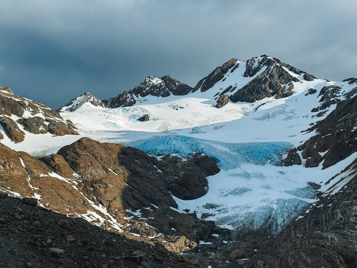
The hike to the glacier viewpoint is short — only about 3.5 km from the parking area — but the trail is steep, muddy, and involves a sketchy suspension bridge over the river. The viewpoint platform gives you a head-on view of the glacier. I stood there for thirty minutes, watching chunks of ice calve off the edges and crash into the lagoon below. The sound echoes off the valley walls. It is thunderous and deeply unsettling in a way that makes you aware of how small you are.
Best hike: Ventisquero Colgante trail — 3.5 km one-way, 2-3 hours round trip. Not long, but steep and muddy. There is also a lower viewpoint if the upper trail is closed (it sometimes is after heavy rain). The Bosque Encantado trail (1 km) through a moss-draped forest is worth the short detour if you have time.
Getting there: On the Carretera Austral, about 165 km south of Chaiten and 100 km north of Coyhaique. Buses between Chaiten and Coyhaique stop at the park entrance if you ask the driver. By car, it is a long day from either town — the road is gravel and slow.
Entrance fee: 5,000 CLP (~$5 USD) for foreigners.
When to go: December to March. The glacier is visible year-round, but the trail closes frequently in winter. Even in summer, bring rain gear — I visited in January and it rained for six of my eight hours in the park.
Cerro Castillo National Reserve — Torres del Paine Without the Crowds
I keep calling Cerro Castillo "the next Torres del Paine," and so does everyone else who has been there. The multi-day trek here offers the same ingredients — jagged basalt spires, turquoise glacial lagoons, wild guanaco herds, massive valleys — but with a fraction of the hikers and none of the booking stress. When I did the four-day Cerro Castillo Trek in early February, I shared the campsite with three other tents. Three.
The highlight is the Laguna Cerro Castillo viewpoint — a glacial lake beneath the park's namesake spires that is so blue it genuinely looks like someone poured dye into it. The climb to get there is brutal — steep, loose scree, about 500 meters of gain in under two kilometers — but the view from the top had me sitting in silence for a long time. It is that good.
The trail infrastructure is still developing. Campsites are basic (think flat spots near water, some with pit toilets), and you need to carry all your food. The route is marked with orange posts but navigation can be tricky in fog. I got briefly lost on day two when the fog rolled in and I could not see more than five meters ahead. A GPS or downloaded offline map is not optional here.
Best hike: Cerro Castillo Trek — 62 km, 4 days, hard. The day hike to Laguna Cerro Castillo (about 16 km round trip from Villa Cerro Castillo) is possible if you do not have time for the full trek.
Getting there: Villa Cerro Castillo is on the Carretera Austral, about 100 km south of Coyhaique. Regular buses connect the two towns (1.5 hours, around 4,000 CLP). The southern trailhead is in the town itself.
Entrance fee: 8,000 CLP (~$8 USD) for foreigners. Register at the CONAF office in Villa Cerro Castillo before starting the trek.
When to go: December to March only. The trail is snow-covered and impassable the rest of the year. February is the sweet spot — slightly fewer people than January, and the weather is marginally more stable.
Patagonia: The Main Event
There is a reason Patagonia is on every serious hiker's bucket list. It is also the reason I kept coming back to Chile. The scale of the landscapes here — the size of the glaciers, the height of the granite walls, the emptiness of the steppe — does not translate into photographs. You have to stand in it. And then you understand.
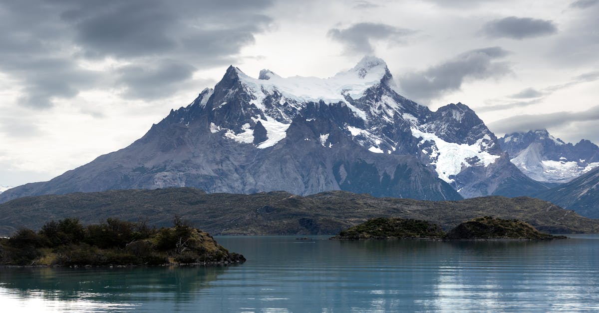
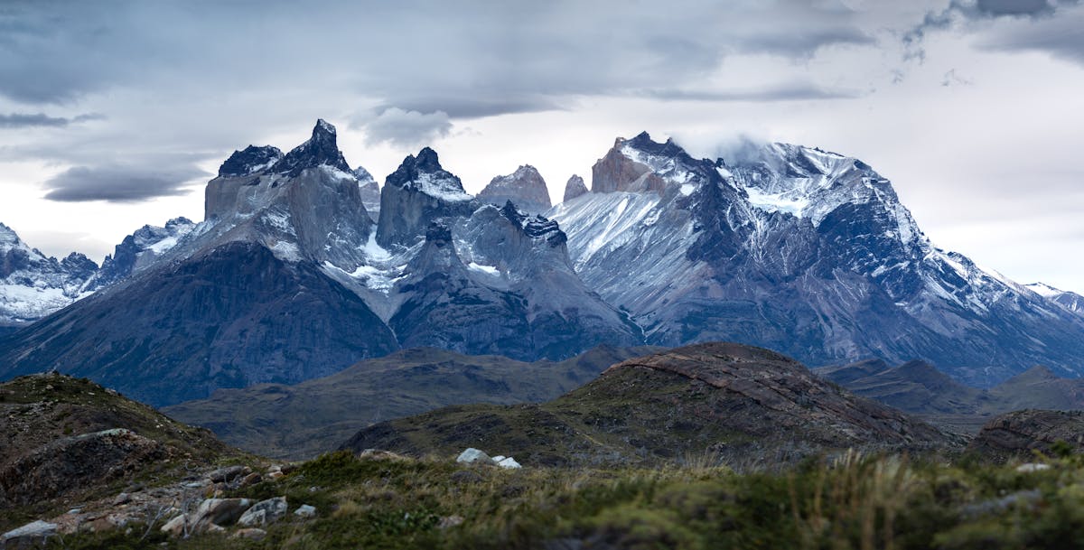
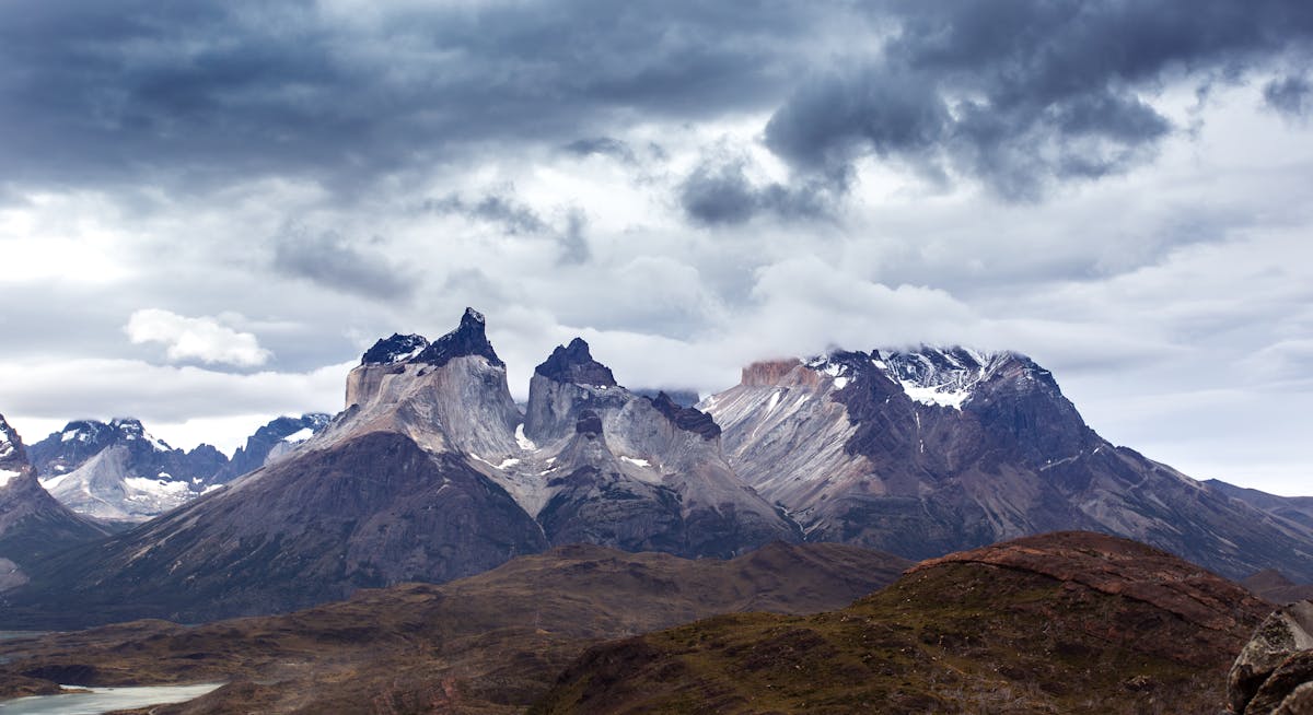
Torres del Paine National Park — The One Everyone Knows
Torres del Paine is the most famous park in Chile, the most visited park in Patagonia, and — I will just say it — probably the most beautiful national park I have been to anywhere. The combination of granite towers, glaciers, turquoise lakes, and windswept steppe crammed into a space you can cross in a few days of hiking is absurd. Nature should not be allowed to pack this much into one place.
I have been twice. The first time I did the W Trek in five days. The second time I came back for the Base Torres day hike and some shorter trails on the eastern side of the park. Both times, the weather tried to kill me and both times the scenery made me forget about it. The wind in particular is something you need to experience to believe. I watched a forty-kilogram backpacker get physically pushed off the trail on the way to the French Valley.
Best hike: The W Trek (4-5 days, 80 km) is the classic. If you have more time, the O Circuit (7-9 days, 130 km) adds the remote backside of the range. For a day hike, the Base Torres trail (22 km round trip) delivers the postcard view. Read my best hikes in Chile guide for details on all three.
Getting there: Fly to Punta Arenas, then bus to Puerto Natales (3 hours), then bus to the park (2 hours). Book the Punta Arenas-Puerto Natales bus in advance during peak season — they fill up. Some hikers fly to El Calafate in Argentina and cross from there.
Entrance fee: 26,000 CLP (~$28 USD) for foreigners in peak season. It is the most expensive park in Chile and worth every peso. Buy your ticket on PasesParques.cl well in advance — the park caps daily entries.
When to go: October to April, with December to February being peak. I preferred late October for lighter crowds and autumn colors in the lenga forests. Check when to visit Chile for seasonal planning. The wind is worst in December-January.
Patagonia National Park — Doug Tompkins' Other Legacy
Patagonia National Park is the newest major park in the system, formally created in 2018 from a combination of Tompkins Conservation lands and the former Jeinimeni and Tamango reserves. It sits in the Chacabuco Valley near Cochrane, and it represents the largest rewilding project in South American history. Huemul deer, pumas, condors, and guanacos are all returning to a landscape that was cattle ranch for a century.
What struck me most about this park was the feeling of recovery. The signage explains what the valley looked like thirty years ago — overgrazed, dusty, fences everywhere. Now the grass is returning, the wildlife is returning, and the trails take you through a landscape that is actively healing. It is hopeful in a way that most environmental stories are not.
The Carretera Austral ends at Cochrane (technically it continues to Villa O'Higgins, but that last stretch is another story), making this park a natural endpoint or turnaround for a Carretera road trip.
Best hike: Sendero Lagunas Altas — 23 km loop, 8-10 hours, hard. Climbs to a series of high-altitude lagoons with views across the entire Chacabuco Valley. The shorter Sendero Tamango (8 km, 3-4 hours) is a good alternative for huemul deer spotting.
Getting there: From Cochrane (6 km to the park entrance). Cochrane is the last major town on the Carretera Austral, about 8 hours south of Coyhaique by bus. There is also a small airstrip with occasional flights.
Entrance fee: Free.
When to go: November to March. The park has a lodge and several campsites — the lodge is excellent and reasonably priced if you are tired of sleeping on the ground. Book ahead at conservacionpatagonica.org.
My Top 5 Ranking
After three trips, too many bus rides to count, and a permanent collection of blisters, here is how I would rank the top five national parks in Chile. This is personal and I know people will disagree. That is fine.
| Rank | Park | Why |
|---|---|---|
| 1 | Torres del Paine | Nothing else comes close for the combination of scenery, trails, and sheer drama. Yes, it is crowded. Go anyway. |
| 2 | Cerro Castillo | The same Patagonian magic without the circus. Give it five years and it will be as busy as TDP. Go now. |
| 3 | Queulat | The hanging glacier is otherworldly. The whole Carretera Austral corridor is incredible, but Queulat is the crown. |
| 4 | Conguillio | The araucaria forests feel like time travel. Llaima volcano is mesmerizing. Nothing else in Chile looks like this. |
| 5 | Pumalin | The alerce forests, the Tompkins story, the sense of what conservation can actually accomplish. A park that gives you hope. |
Torres del Paine at number one is not a surprise — it earns it. But the real recommendation here is Cerro Castillo at number two. That park is having its moment right now, where it is developed enough to be accessible but not yet famous enough to be overrun. In five years, the trail will have refugios, the campsites will require advance booking, and the prices will triple. The window to experience it the way Patagonia used to feel is closing.
Honorable Mentions
Lauca would be top five if it were easier to reach. Huerquehue is the best bang-for-your-buck day hike in the country. And Pan de Azucar is the one I keep telling people about at dinner parties because nobody believes penguins live in the desert.
Practical Stuff That Applies to All Parks
Entrance Fees and Passes
Most Chilean national parks charge between 4,000-8,000 CLP ($4-8 USD) for foreign visitors, with Torres del Paine being the expensive outlier at 26,000 CLP. Chilean residents pay significantly less. Some parks (Pumalin, Patagonia NP) are still free. Buy tickets on PasesParques.cl in advance — the website is in Spanish but manageable with Google Translate.
Getting Around
Chile's national parks are not set up for car-free travel the way European parks are. A few (Torres del Paine, Huerquehue, Vicente Perez Rosales) have decent bus connections. Most of the rest — especially along the Carretera Austral — essentially require a car. I rented from Econorent in Puerto Montt for my Carretera Austral trip and it was the single best investment of the whole journey. Budget $40-60 per day for a basic car.
When to Visit Chile for National Parks
The short answer: November to March for most parks. The long answer depends on the region. The northern parks (Lauca, Pan de Azucar) are good year-round. The Lake District and Carretera Austral parks are only fully accessible in summer. Patagonia has the shortest window — December to February is prime, with shoulder months of November and March offering fewer crowds but less predictable weather. Read the full breakdown in my when to visit Chile guide.
What to Pack
Layers. Always layers. Chile can throw four seasons at you in a single day, especially in Patagonia and the Lake District. My standard kit for every park hike: base layer, fleece, waterproof shell, sun hat, warm hat (yes, both), sunscreen, and at least two liters of water. For the Carretera Austral parks, add gaiters and waterproof pants. For the northern parks, add sunblock with SPF 50 and electrolyte tablets — the altitude and dry air dehydrate you faster than you realize.
Thirteen parks. Forty-six if you count all of them. The thing about Chile is that the country keeps going after you think it should stop. Every time you look at the map and think you have reached the end, there is another fjord, another glacier, another volcano, another forest older than written history. I have been three times and I still have not seen Bernardo O'Higgins, Cape Horn, Rapa Nui, or the Marble Caves. The list never gets shorter. It only gets longer. And honestly, that is the best problem a traveler can have.